


The beginning of May marked the start of the highly anticipated lingcod fishery on the East Coast of Vancouver Island. With voracious appetites, these hard-hitting predators make for excellent sport, but their preference for highly structured habitat presents challenges to the unprepared angler.
Your chart plotter and sounder are extremely useful tools for identifying key lingcod habitats and planning a strategy to target these toothy piscivores.
In writing this article, I am making the assumption that you have already visited a local tackle store, and have procured the required rods, reels and terminal tackle. A basic sounder and paper charts will get you in the game, but your odds of success will be greatly enhanced with upgraded electronics.
A modern multifunction display (MFD) combines a GPS receiver, with a chart display and a depth sounder. When combined, these three data sources become a very potent tool for the ling hunter.
An accurate GPS sensor with 10 Hz refresh rates (providing location updates ten times a second) keeps you aware of your precise position in regards to drop-offs, ledges, rock piles and reefs. A dedicated external GPS antenna (such as the Point-1 from Lowrance) provides the best accuracy, and a built-in heading sensor keeps the cursor on your charts pointed in the same direction as your vessel’s bow regardless of influences from wind and currents. That’s important because in the right location there will be current and most likely wind. Now that we know where we are, what are we looking for? Steep and rocky. A good set of charts helps us eliminate a large portion of ocean floor that does not meet these criteria. Many software providers market sonar-generated charts, created from tide corrected sounder recordings from local boaters. With this data, we can view charts with bottom contour intervals as small as one foot.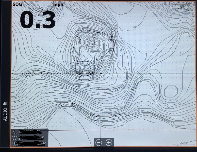
This becomes very useful when searching out small ledges and rock piles. Focus on areas that show many closely spaced lines interspersed by short and irregular intervals between the contours. If there’s kelp nearby, all the better, as it concentrates smaller forage fish that keep lingcod nearby. Many reefs will be indicated by name or letter (R for rock/reef). Avoid flats or sand/mud bottoms (indicated by M or S on the charts) as they may hold the odd lingcod, but as a rule, one percent of the ocean floor holds ninety-nine percent of the fish.
With our potential lingcod holes narrowed down by interpreting our electronic charts, and our position and heading indicated by the cursor on the chart plotter, the work has just begun. Bouncing a jig on the bottom in a high-topography area can be an expensive habit if not done strategically.
Upon approaching a potential lingcod spot, turn on the tracks on your chart plotter, put the engines in neutral and prepare your gear. Let the tide and/or wind push you. Take note of the direction of your drift and compare it to the topography on your charts. Select a spot that will have your boat drift from shallow to deep water and allow you to cover as many drops and ledges as possible. Drifting towards deeper water and letting line spool out, with the occasional tap on the bottom, keeps your bait or jig in the strike zone.
Drifting to shallower water becomes a hazard, as your gear is more likely to drag along bottom and become hung up.
The final ingredient to a successful electronic lingcod pursuit is your sonar. In shallower waters (to 100 feet), a quick scan of your target area with a high-frequency imaging sonar will make you aware of any gear-grabbing obstacles such as weed beds, submerged cables, and sunken debris. A traditional or chirp sonar when used on higher frequency settings (200khz or high chirp) gives an accurate cross-section of the terrain directly under the boat.
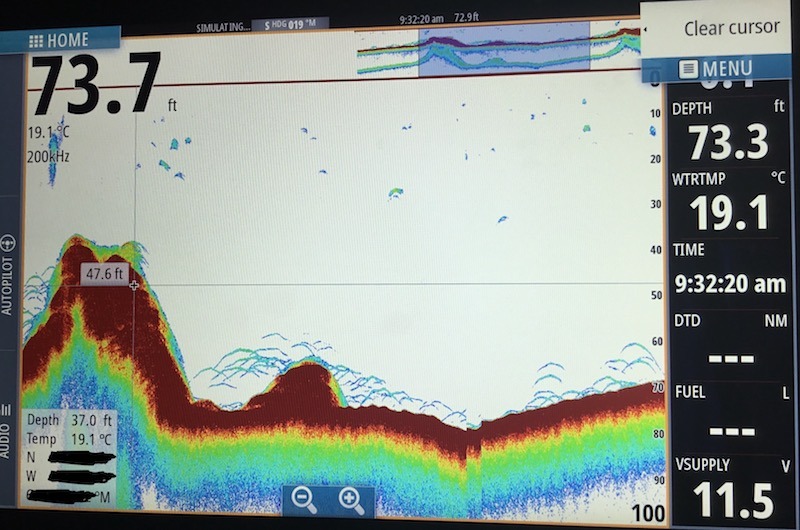 Bottom composition can be determined by the nature of the image; imaging sonar will display hard structure as brighter areas while traditional and chirp sonars will display a solid bottom as a thinner line, while less dense areas are shown as a thicker line.
Scan depths from 20 to 300 feet in depth. Make special note of any fish arches close to bottom. A modern touchscreen MFD will allow you to pause the sonar, scroll back through the history and place a cursor over areas of interest and with a couple of key presses, and mark a waypoint on your charts right on top of fish holding areas. Gear tied, habitat located, and a good drift planned over a few waypoints, it’s time to put it all together.
Motor upwind or upcurrent of your waypoints. Line the stern of your boat to face directly into wind or tide and use the kicker motor to control drift speed. With a fast but controlled drop, lower your lures or bait and tap bottom, reel up a couple of turns, then repeat. Every few seconds, free spool back down to bottom, engage your reel and wind up. Keep an eye on the sonar; should the water become shallower, reel in quickly or risk losing terminal tackle. If unsuccessful, line yourself up 20 feet to either side of your previous drift and cover the area in a systematic approach.
Keep your rod tip low to the water, ready for a hook set. When a lingcod strikes, you’ll know it! Keep pressure on the fish until well clear of bottom to prevent abrading your line on the reef and breaking you off.
Be sure to mark a waypoint where your fish was hooked; when a lingcod is removed from a prime ambush spot, often another will move right in to occupy the same location.
I hope I’ve provided you with a few new tools for your fishing arsenal. As always, enjoy your time on the water, practice safe boating habits and please respect the ban of fishing in Rockfish Conservation Areas.
One Comment
Leave A Comment
Visit the Store
$34.99

$34.99


Featured Catch

Joel Unickow halibut (Photo: Rob Frawley Lucky Strike Sportfishing Tofino)


Moose has fish repellent in his veins ;)